AEC Reality Capture Solution
Capture, Analyze and Distribute AEC Data Faster
For AEC we can provide a number of services which assist workflow and visualisation throughout a project lifecycle.
Streamline documentation, 3D scan as-builts, and collaborate remotely with ease from anywhere.
Increase efficiency with a fast, affordable capture service
Track, Share & Export
The Matterport Pro3 3D camera is a reality capture solution for the South Carolina Architecture, Engineering and Construction industry. By using a Matterport Pro3, you can capture accurate measurements and visual documentation to keep track of key project milestones and immediately assess project status.
Our Pro3 camera/scanner quickly captures immersive and accurate digital twins of any interior or exterior space. The Pro3’s 20 megapixel sensor and LiDAR-powered capture technology range up to 100 meters and can capture large spaces in remarkable detail. The 3D data captured by the Pro3 camera can be exported as a point cloud into any CAD program. The point cloud, combined with the 3D visuals, can then be used to create a BIM for your project.
Streamline documentation, 3D scan as-builts, and collaborate with ease.
AEC Workflow
Capture as-built construction

Engage with stakeholders virtually with the same richness of experience as an in-person site visit.
%
%
%
Testimonials
Key
Benefits
Fast and More Complete than 3D laser scanning
NO REGISTRATION MARKERS REQUIRED
Our 3D scanning process is push-button simple. No registration markers and no manual alignment required. Everything is automatic!
ACCURATE WITHIN 1%*
Scanning is not only quick but also accurate enough to generate point clouds and polygons for as-builts and construction documentation.
Jump start your as-builts with a 3D Model
QUICKLY SCAN CURRENT CONDITIONS
3D scanning as-builts has never been easier. No need to set up registration markers before you scan, and your point clouds are automatically registered in the cloud for one less step.
BE EFFICIENT, MEASURE WHILE OFFSITE
No need for return site visits when you have a complete 3D model on your computer. Your as-built engineers can reference the complete space throughout the design process, collecting virtual measurements whenever they need to. As built documentation has never been easier.
EXPORT POINT CLOUDS INTO AUTODESK® RECAP
You can easily export a registered, colored point cloud that is ready for Autodesk® ReCap. Use a point cloud as a real-world template to kickstart your as-built design process.
BIM: Faster building information modeling
REDUCE VIRTUAL DESIGN AND CONSTRUCTION COSTS
Make the scan the first step in your BIM process. Use it to to visually analyze a property, export the registered point cloud into your BIM modeling software, and start modeling from existing conditions.
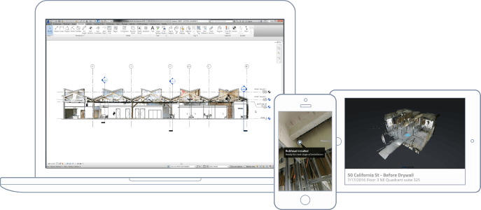
WIN MORE BIDS WITH BETTER DOCUMENTATION
Building owners want the construction of their buildings to be well documented. Provide them with superior construction documentation throughout the process. When you’re done, give them the files they need for long-term facilities management.
Keep your documentation costs low while still offering accurate, high-quality information.
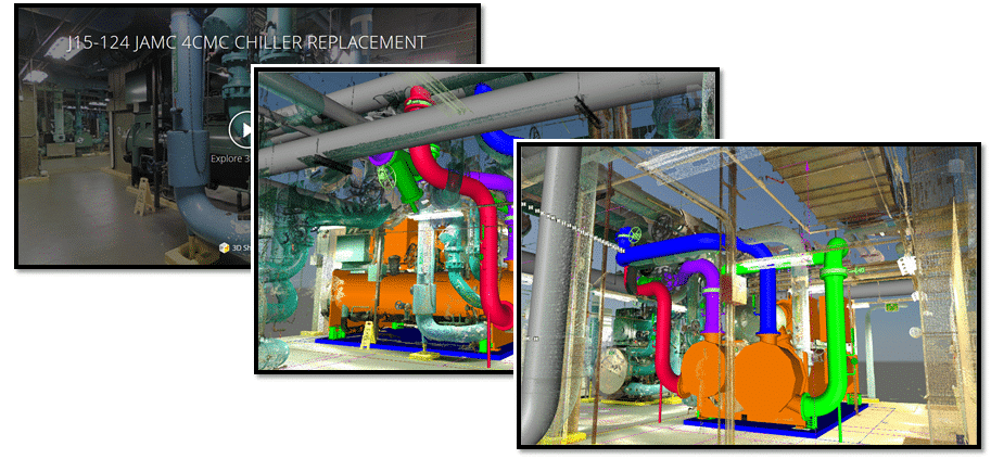
GET THE POINT CLOUD AND MAKE MEASUREMENTS
Get the point cloud from Matterport, import into Recap or Revit, and then take as many measurements as you want. Measurements are accurate to within 1% of reality.
With a point cloud, you can eliminate return visits because you always have a digital copy from which you can measure. You can also take measurements that are difficult to get in real life like pipes, trusses, and beams in the ceiling.
Documentation Optimisation
3D CONSTRUCTION DOCUMENTATION WITHOUT THE HEADACHE
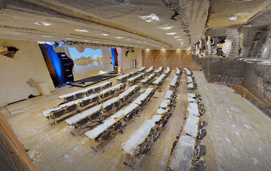
With only a few simple scans, we can give you quick and effective milestone documentation. With both 2D photography and 3D data, it’s the best way to track key milestones and discover issues early.
Replace 1000s of photos
For when you absolutely need 2D photos, they’re easy to download from the scan. You can also get reflected ceiling plan images and high resolution floorplan images for even richer documentation.
Measure, Annotate and Communicate Faster
Get the point cloud that accurately details current conditions and then export to Revit to compare with the original design.
Leverage for the long term
When the project is complete, we simply turn over your collection of 3D Spaces (captured at different phases) to the building owner and facilities manager as part of your turnover package. They’ll continue to use it for long-term management and maintenance.
No leveling, registration markers, or manual alignment required.
Our powerful vision pipeline automatically aligns and stitches your 2D and 3D data into a complete textured mesh that’s as real as being on-site.
Finally, export assets (point cloud, reflected ceiling and floor plan images, 3D mesh file, 2D photos, and more) and continue working in other software that you already use.
Trusted By


